.jpg)


.jpg)

 English daily published in Bengaluru & Doha

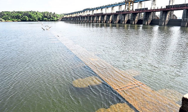
Coast waits as water level drops, skies stay uncertain
Mangaluru
Coastal Karnataka is once again at a critical seasonal juncture, where rising heat, falling water levels and uncertain rainfall are unfolding together, testing both systems and public patience. At the centre of the concern is the Thumbe dam, the primary source of drinking water for Mangaluru, where levels have dropped to around 4 metres. While such levels are not unusual at the peak of summer, the pace of decline and early timing have raised concern. MCC has introduced alternate day water supply in parts of the city, indicating a shift from routine to controlled distribution. On the ground, the impact is already visible.
Households are adjusting consumption, tanker demand is steadily increasing and borewells are being pushed harder. What was once a late summer concern has now arrived earlier, leaving very little buffer before the monsoon steps in. Parallel to this is the steady rise in heat across Dakshina Kannada and Udupi districts. The pattern remains familiar, cloudy mornings offering brief relief, followed by sharp humidity and uncomfortable afternoons. But the difference this time is in the nights. Minimum temperatures have gone above normal reducing recovery time and adding to overall fatigue. This overlap of rising heat and falling water levels defines the current phase.
When heat goes up, water usage increases. When water levels go down, supply tightens. Both are happening at the same time now making even a short delay in rainfall more critical than before. There is some relief expected. Weather activity is likely to build up along the coast in the coming days, with chances of thunder showers, lightning and gusty winds. If it arrives as expected, it will bring immediate cooling and some breathing space to the system. But this is not a complete solution. Pre monsoon rains in this region are usually uneven and short. A quick spell may cool things down, but it will not recharge water sources unless it continues.
Depending on these early showers alone is a risk. Speaking to NewsTrail, R Sajeev, Scientist from Doppler Weather Radar Mangalore said coastal areas may remain around 2 degrees lower than interior regions due to the sea effect, but humidity will continue to make conditions uncomfortable. He said thunderstorm activity is expected and advised caution during sudden weather changes, especially in the evenings and nights when pre monsoon showers are likely. Adding to this, Sajeev said the current pattern points to a mixed monsoon outlook.
The initial phase of rainfall is expected to be near normal or close to seasonal average, but there are signs of deficient rainfall in the second half of the monsoon, influenced by the El Niño effect. He also noted that temperatures are likely to rise further towards the last week of May, which typically supports monsoon onset conditions. This phase may bring thunderstorm activity and temporary relief from heat, but consistency in rainfall remains the key concern.
Residents have also been advised to avoid direct sun exposure between 12 pm and 3 pm, when heat stress is highest. Interior areas like Puttur and Kadaba are already seeing sharper temperature increases compared to the coast, showing how uneven the situation is. These pockets are likely to feel more stress if rainfall remains inconsistent. What is becoming clear is that this is no longer just a seasonal issue. The gap between peak summer and dependable rainfall is becoming tighter and more unpredictable.

.jpg)

.jpg)